The ‘protection gap’ refers to the difference between the economic loss from a catastrophe and the amount of loss covered by insurance. Here we explore the possible economic impacts of just one type of very large catastrophe – volcanic eruptions – that are frequently ignored by the insurance industry even though coverage may be extensive in some regions for many portfolios. We end by considering some potential insurance issues.
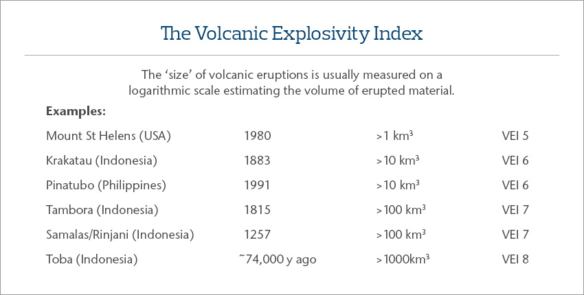
Large volcanic eruptions are rare. Measured on the Volcanic Explosivity Index (VEI), VEI eruptions of magnitude 7 occur somewhere in the world, on average, about twice in 1,000 years. Very large VEI 7 and VEI 8 eruptions are even rarer, with only six recorded in the last 100,000 years – one in Italy, one in New Zealand, one in Indonesia, and three in Japan – an average of about one in 17,000 years (Rougier et al., 2017).
 While VEI 7 and 8 eruptions are much less common than, for example, M 9.0 earthquakes, their consequences are much more widespread, and the losses much more severe.
We now know that almost all the significant climate variation in the world during the past 1,000 years (apart from the global warming of the 20th and 21st centuries) has resulted from VEI 6 and 7 explosive eruptions injecting vast quantities of sulphur dioxide into the upper atmosphere. The VEI 7 Tambora eruption of 1815, for example, resulted in crop failure in the northeastern United States and the ‘year without a summer’ (1816), and contributed to such dismal weather across most of central Europe that Mary Godwin (later Shelley) was encouraged to pen Frankenstein while housebound in Switzerland. It seems likely that the Samalas/Rinjani eruption in 1257 triggered the onset of the Little Ice Age with subsequent VEI 6 eruptions sustaining it for several centuries (Newhall et al., 2018).
Here we outline some of the potential economic and insurance consequences of a large VEI 7 eruption, up to 10 times larger than the 1815 Tambora eruption, and nearly 100 times larger than the Krakatau eruption in 1883. We consider the consequences of such an eruption at three scales – proximal (within 100 km or so of the volcano), distal (extending downwind 1,000-2,000 km), and global. While VEI 7 eruptions are rare, Newhall et al. (2018) identify 125 volcanoes around the world that may be candidates to produce such an eruption in future millennia: 13 in Eurasia, 5 in Africa, 17 in Oceania, 22 in Southeast Asia, 32 in East Asia – North West Pacific, and 36 in the Americas and Caribbean.
Proximal consequences
In large explosive eruptions vast quantities of hot ash, rock, and gas are ejected from the vent to heights of a few kilometres at rates that exceed tens of thousands of cubic metres of material per second (possibly even hundreds of thousands of m3/second). Convection and entrainment of the surrounding air causes the eruption column to rise to heights exceeding about 40 km. Large parts of the column fall back to earth and extend around the volcano as pyroclastic density currents (PDCs); these avalanches of gas, rock, and ash may have temperatures greater than several hundred degrees Celsius, attain speeds of 100 m/s and extend 50-100 km from the vent. This climatic phase of the eruption probably lasts less than a day or two. The PDC deposit left behind after the eruption is likely to be several hundred metres thick near to the vent, thinning to less than a metre or two at the margins. The thicker parts of the deposit will take at least several years to cool to normal temperatures.
Destruction of all life and all infrastructure within the PDC zone will be total except (perhaps) at the very margins of the PDCs. For the VEI 7 eruptions from the past where we have reasonably good data, this PDC zone of total destruction extends 50 to >100 km from the vent; i.e. the zone of 100 percent insured and economic losses extends across 8,000 to >30,000 km2 (for comparison, an area much larger than nearly all the largest cities in the world). Human populations living within 100 km of the 125 potential VEI 7 eruption sites identified by Newhall et al. (2018) range from a few thousand to about 25 million.
Distal consequences
The ash and gas that is lofted high in the eruption column above the volcano drifts off downwind and falls back to earth under the influence of gravity, wind velocities and directions at the time, and (at lower elevations) rainfall. The resulting deposit generally becomes thinner and the ash particles finer with distance from the vent, and with distance from the axis of the ellipse of deposition.
As we might imagine, the areas covered by ash fall in VEI 7 eruptions is stupendous. The Oruanui eruption at Lake Taupo in New Zealand about 27,000 years ago produced an ash fall of 50 cm some 500 km downwind and about 18 cm in the Chatham Islands, 800 km downwind (Lowe, 2013). These, and all other thicknesses reported here, are compacted thickness – within a week or two of an eruption the freshly-fallen ash compacts to about half its original thickness. The relatively small VEI 7 Aira eruption in southern Kyushu, Japan, about 28,000 years ago caused an ash fall in the area of present-day Tokyo of about 15 cm and as much as 1 cm in Hokkaido about 1700 km to the northeast of the volcano (Machida, 1999). As a further example of the extent of VEI 7 ash falls, more than 25,000 km2 experienced a (compacted) ash fall of 50 cm or more following the Tambora (1815) eruption, about 450,000 km2 of 5 cm or more, nearly one million km2 an ash fall of one cm or more, and more than 5.6 million km2 of one mm or more.
Volcanic ash has deleterious effects on humans, livestock, buildings, infrastructure, agriculture and other economic activity with the degree of damage depending not only on ash fall thickness but also on grain size, abrasiveness, surface chemistry (e.g. attached sulphuric and hydrochloric acids), and the weather during and following the eruption (particularly rainfall and wind). Here we illustrate the potential consequences for humans, buildings, and crops focusing particularly on the effects of compacted ash thicknesses.
The impact on humans
At distances from the volcano just beyond the area of pyroclastic density currents where no humans survive, ash fall thicknesses are likely to range 50-100 cm and more. Compacted thicknesses in this range will cause many residential building roofs to collapse, leading to human deaths and serious injuries. Given the widespread nature of ash fall in large eruptions and the possibility that the eruption is continuing, rescue and hospitalization of the injured would be challenging.
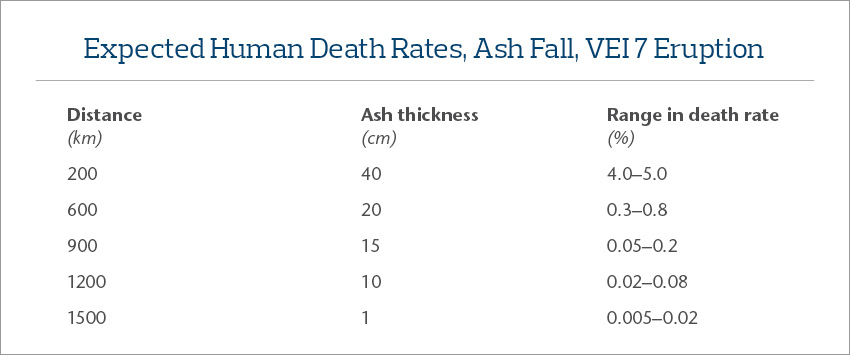 At greater distances with thinner ash falls, few roofs collapse, but humans are still at risk, particularly those with pre-existing respiratory illnesses and other health issues. Roads are made slippery by ash falls of even a few millimetres – motor vehicle accidents are likely to increase and infrastructure and emergency services to be compromised. The table reports our view of the likely range in death rates for a range of ash fall thicknesses and distances based on limited real-world data and modelling results. Even at a distance greater than 900 km downwind from the vent the human death rates from respiratory and other health effects of the ash fall are likely to reach between 1-in-500 and 1-in-2000 people.
The lowest total death tolls will depend on total evacuation prior to the eruption from the areas subject to pyroclastic density currents. As suggested earlier, even the low death rates distant from the volcano could mean that the human death toll ranges from just a few thousand individuals to (potentially) several million.
Many populations benefit from insurance cover for death or injury. While we anticipate substantial variations in cover across countries even the lowest death tolls suggest life and annuity costs of several to many billions (in USD). Such preliminary estimates do not take into account workers’ compensation cover, short- and long-term morbidity, injuries resulting from cleaning up the ash fall, dangerous driving conditions, changes in psychological functioning, or deaths or injuries resulting from the very common remobilization of settled volcanic ash during subsequent years. Nor are the potential costs of evacuation/alternative accommodation, possibly for several years, considered.
Building vulnerability
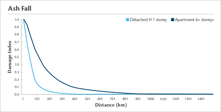 We have produced vulnerability curves for a range of residential, commercial and industrial buildings subject to the fall of volcanic ash. The figure below shows examples of damage curves for two residential building types, using distance from the source of the VEI 7 eruption as a surrogate for compacted ash fall thickness. These curves ignore the reality that all buildings within 50-100 km of the vent have already been destroyed by PDCs. While, in this example, losses for single storey detached houses more than 700-800 km from the eruption source appear negligible, it should be remembered that ash falls of a few centimetres or less could cover land areas of more than a million km2, potentially producing small losses to tens to hundreds of thousands of insured properties. For example, a repeat of the VEI 7 Aira eruption in southern Japan about 28,000 years ago would deposit volcanic ash on more than 30 million residential buildings.
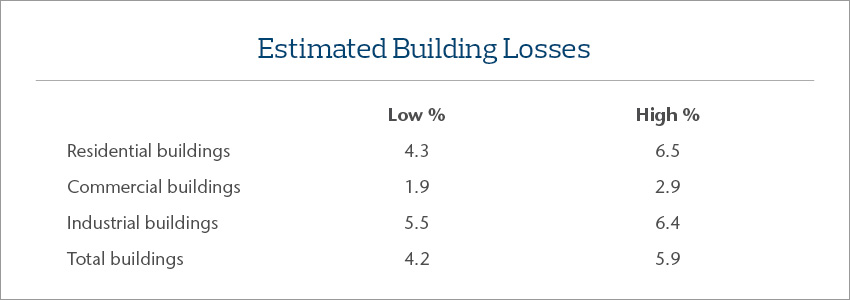 The table shows expected losses (PDC + ash fall) for the entire residential, commercial and industrial building portfolio in a country subject to a VEI 7 eruption with the largest population centre located more than 900 km from the source. These estimates translate to a total building loss of roughly USD300-450 billion. Obviously, actual losses would depend on the relationship between building assets and the location of the volcano – actual losses could range from a few billion USD to several trillion USD. We have not included any allowance in this estimate for alternative accommodation, debris removal, professional fees, or building contents; nor have we considered potential losses from other volcanic perils such as tsunami during or mudflows (called lahars) after the eruption.
Crops
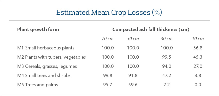
Our analysis of potential crop losses as a result of the fall of volcanic ash assumes that the most important plant characteristic is the physiognomy of the plant, in particular the height above the ground and hence sensitivity to burial by volcanic ash. Following MIAVITA (European Commission funded project from 2008 to 2012 to ”Mitigate and Assess risk from Volcanic Impact on Terrain and human Activities) we divide crops into five classes (see ‘Estimated mean crop losses’ table). Other criteria important in assessing the survival/damage to crops include growth phase at time of the ash fall (planting, growth, harvest, fallow season), the nature of the crop (e.g. smooth-skinned or glabrous, above or below ground), ash grain size and surface chemistry, the effects of the ash fall on insect pollinators and predators, and subsequent wind and rainfall. We have developed high and low estimates of potential losses, summarized in the table below as mean loss estimates for four ash fall thicknesses and each of the five plant growth forms.
Several observations are particularly relevant. Firstly, the M3 category is likely to be by far the most important as cereal crops are included here. Secondly, following Wilson et al. (2015) 30 cm or more of ash fall will likely cause retirement of land from horticultural, arable, pastoral, and paddy production for at least several years. In one of our studies, this suggested the land producing 30 percent of the value of the entire country’s agricultural production would be sterilised for some years. Finally, estimates made after the quite small 2011 Shinmoedake eruption (VEI 2) in southern Japan, suggested that crop losses accounted for only about half of the on-farm economic losses (Magill et al., 2015).
 Obviously, the quantum of losses, insured and uninsured, from a VEI 7 eruption depends on the density and distribution of people and assets in the areas affected by pyroclastic density currents and ash fall. It is unlikely that economic losses in terms of human deaths and injuries, building loss, and agricultural destruction resulting from a VEI 7 eruption at any of the 125 potential locations identified by Newhall et al. (2018) would be less than several billion USD. For several sites losses could exceed several trillion USD. These broad estimates also ignore transport and infrastructure losses, those produced by business interruption and marine and port losses resulting from the vast sheets of floating pumice clogging coasts within hundreds of kilometres of the eruption, and animal and fish farming losses.
Despite the magnitude of likely losses within the proximal and distal zones, other economic costs triggered around the world are likely to be larger.
Global
While large volcanic eruptions produce severe damage across thousands to tens of thousands of square kilometres around the volcano, the global consequences may be even more severe. Many, but not all, large eruptions inject megatons of sulphur dioxide into the stratosphere, creating sulphate aerosols which over the next few years circle the globe and backscatter incoming solar radiation. The reduced solar radiation generates surface cooling, altered atmospheric and oceanic circulation patterns linked to semi-global phenomena including the Atlantic meridional overturning circulation, ENSO, the Pacific Decadal Oscillation, tropical monsoons and associated variable direct and indirect consequences at regional scales.
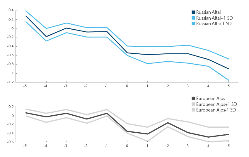
While the atmospheric changes produced by a VEI 6 or 7 eruption are complex, the common signal from analysis of annual tree ring growth rates before and after the eruption is summer cooling; i.e. cooling in the main crop growth season. The diagram below summarises summer (JJA) temperature anomalies using superposed epoch analysis for the 20 largest volcanic eruptions in the Common Era. The upper panel infers summer temperatures from tree ring growth in the Russian Altai; the lower panel shows similar data from the European Alps (two areas of the world with the highest quality data) (data after Büntgen et al., 2016, SI, Fig S10).
While the post-eruption temperature anomalies, at 0.5-1.0oC, seem small it should be remembered that the difference in average global temperature between the last full glacial maximum (18-20,000 years ago) and the present day is only 5-6oC. Furthermore, only four of the twenty eruptions for which detailed temperature data can be reconstructed were larger than VEI 6 eruptions. Equally importantly, the eruption-induced lowering of average summer temperatures lasts at least four or five years and we would expect similar cooling across most regions of the globe.
It is difficult to model with any certainty the consequences of a VEI 7 eruption for global agriculture as the changes will depend on the sulphur aerosol content of the eruption cloud and associated plumes and their spread across the world in the following weeks, the state of El Niño at the time of the eruption, local and regional changes in temperature, precipitation and solar radiation. We know that the VEI 7 eruption of Tambora in 1815 resulted in decimated crops in central Europe and eastern North America, but outside these areas we have a limited notion of the specific consequences. In Switzerland, for example, more rainy days, cooler temperatures, and increased cloud cover had a large negative effect on plant growth but in Spain large areas were in drought (Brönnimann and Krämer, 2016).
While a temperature change of minus 1oC seems relatively minor (and perhaps comparable to but opposite in sign to the plus 1oC change associated with about 25 years of global warming), the change following a large eruption is much more abrupt. With this in mind, the consequences of a VEI 7 eruption for global agriculture are likely to be profound. Extrapolating, the modelling results shown by Puma et al. (2015) indicate the potential annual production losses for wheat, maize, rice and soybean for a present-day VEI 7 Tambora eruption would be equal to the food for 2.3 billion people on a caloric basis assuming a world average diet of 2,940 kcal per capita per day. Equivalent potential annual production losses for a present-day repeat of the 1257 Samalas VEI 7 eruption would be equal to around 0.3 billion people, and for the 1600 A.D VEI 6 eruption of Huaynaputina (Peru), three billion people. As global food supply is approximately equal to demand (with a three-month buffer), these losses suggest global agricultural production would fall by anywhere from 5 percent to more than 40 percent of requirements. The value of global annual cereal production is more than USD500 billion, and the annual value of all agricultural production about USD2.4 trillion. As indicated earlier this production gap and economic loss would likely continue for several years.
Further, we might expect air transport to be disrupted hemispherically for some weeks and global trade particularly in agricultural products would be affected for some years. While some parts of the world may remain little affected, in others local and regional food shortages are almost certain to lead to famine, migration, riots, political and social changes and, possibly, disease. As with all major catastrophic events, the potential consequences need to be considered in relation to the ‘state of the world’ (and the economy) before the event occurs.
Clearly, arriving at worthwhile estimates of the global economic losses from a super eruption is not yet possible, but they are very unlikely to be less than USD1 trillion (in addition to the proximal and distal losses suggested earlier) and possibly considerably more. While super eruptions of VEI 8 are unlikely, with global return periods currently estimated at about, on average, once in 17,000 years, VEI 7 eruptions similar in magnitude to Tambora in 1815 and Samalas in 1257, have global return periods of about twice in a thousand years. Furthermore, a sequence of VEI 6 eruptions occurring within a decade or so may have global consequences similar to a super eruption or to the eruptions between 536-541 A.D. which produced the coldest decade in the past two millenia, or to those in the 14th to the mid-19th century commonly judged to have initiated and sustained the so-called Little Ice Age.
Insurance implications
A VEI 7 eruption would have profound effects for insurers and reinsurers across the world. Some of the potential consequences, and some insurance issues, resulting from a VEI 7 eruption anywhere in the world are summarized below:
- Insured losses as a proportion of economic losses vary country to country, portfolio to portfolio, and risk to risk. For the more than 90 catastrophe events included in Sigma reports for 2015-2017, insured losses average 48±25 percent of economic losses with a range extending from 1.5 percent to 82.5 percent, the range reflecting not only variations from region to region and from peril to peril but also, no doubt, the quality of the estimates of economic losses. Similarly, the protection gap will vary from small to very large, but it is unlikely to ever be very small.
- Losses to all assets – organic and inorganic – out to a distance of more than 50 km from the vent are likely to be total.
- VEI 7 eruptions are likely to provide a year or more of warning signs before the main event (which would probably last only a few days). However, it may be difficult to forecast the potential magnitude of the eruption until a few days/weeks beforehand.
- A lengthy waiting/warning time probably has significant implications for re/insurers. What would happen to investment and employment within 100 km of the potential source volcano? Would insurers withdraw/reduce volcanic eruption cover? Would building fire losses increase pre-eruption? Are volcanic eruptions essentially explosions – and thus covered by clauses in addition to those relating solely to volcanic eruption?
- Apart from total losses within around 50 km or more from the volcano, a small proportion of people would die from respiratory and other diseases, roof collapses, vehicle accidents and so on hundreds of kilometers from the vent.
- In many cases the average citizen will hold a variety of ‘death benefits’ – the cost to insurers could be substantial. ‘Normal’ deaths will also occur in the year of the eruption, adding to the burden on the life industry.
- None of this discussion has considered injuries, life-threatening or otherwise, those with claims resulting from workers’ coverage, subsequent trauma, or deaths resulting later from remobilization of the unconsolidated, unvegetated ash.
- With total losses to buildings within 50 km or more of the vent, damage could extend more than 1000 km from the eruption source. Infrastructure and commercial activities would be similarly affected.
- Agricultural losses may vary by time of year (planting, growth, harvest, fallow season), except within 50 or more kilometres of the vent where they will be completely destroyed. Losses will also vary crop-by-crop but cereals and legumes are particularly vulnerable because of their growth form – they also make up the bulk of world crop consumption and account for the majority of insured crop value.
- Where PDCs (pyroclastic density currents) and/or ash falls greater than 30 cm occur, agricultural losses are likely to be multi-year and extend several hundred kilometers from the vent.
- Elsewhere, within 1000-2000 km of the source volcano, the mix of crops, their values, growth stages, the thickness of the ash and its chemical and physical properties, and the effects of the ash fall on crop predators, together with subsequent weather, will influence the quantum of loss. Other on-farm losses may well equal crop losses in value.
- Global agricultural losses following a near super eruption are difficult to quantify, but few areas of the globe are likely to be unaffected, consequences are likely to extend for several years, and flow-on effects may well extend to less obvious insurance covers.
The losses, insured and uninsured, that would follow from a large VEI 7 (or a VEI 8 eruption) extend globally, span several years and influence negatively many aspects of our lifestyle. Traditional risk mitigation methods such as land use planning and strengthening of buildings would seem to be of limited value except in areas tens of kilometers from potential eruption sources. Evacuation of humans, and livestock, and early harvesting of food crops sound practical, but the areas potentially affected are vast and abandonment of cities and countryside could extend for years. Two issues may be worth in-depth analysis: (i) if 12 months’ warning of the timing and location of a VEI 7 eruption was possible what steps should an insurer (or government) take to retain the support of their clients (citizens) and to maintain the economy?; and (ii) while ‘volcanic eruption’ is often covered in insurance policies and a VEI 7 eruption has a roughly 1-in-500 year chance of occurring somewhere in the world, it seems unlikely that policy wordings have been thought through with the potential for near-global consequences in mind.
About the authors
This report was a collaboration between Russell Blong and Aon colleagues based in Sydney, Auckland and Japan.
Russell Blong
Emeritus Professor Russell Blong was on the staff of Macquarie University, retiring in 2003 as foundation Director of Risk Frontiers, a research centre funded largely by the global insurance industry. He has authored or edited ten books including several on volcanic hazards. Russell works part-time as a consultant for Aon in Sydney on the consequences of a number of global hazards.
References
Brönnimann S and Krämer D, 2016, Tambora and the “Year Without a Summer” of 1816: a perspective on earth and human system science, Oeschger Centre Climate Change Research, Geographica Bernensia, University of Bern, 49p.
Büntgen U et al., 2016, Cooling and societal change during the Late Antique Little Ice Age from 536 to around 660 AD., Nature Geoscience, 9, 231-236. DOI: 10.1038/NGEO2652.
Lowe DJ, Alloway BV, Shane PAR, 2015, Far-flown markers. In: Graham IJ (editor), A Continent on the Move: New Zealand Geoscience Revealed, Second Edition, Geoscience Society of New Zealand in association with GNS Science, Wellington, pp. 172-175.
Machida H, 1999, The stratigraphy, chronology and distribution of distal-marker tephras in and around Japan, Global and Planetary Change, 21, 71-94.
Magill C, Wilson T, and Okada T, 2013, Observations of tephra fall impacts from the 2011 Shinmoedake eruption, Japan, Earth, Planets, Space, 65, 677-698.
MIAVITA, 2012, Handbook for Volcanic Risk Management - Prevention, Crisis management, Resilience, European Commission, Orleans, 204p.
Newhall C, Self S, Robock A, 2018, Anticipating future Volcanic Explosivity Index (VEI) 7 eruptions and their chilling impacts, Geosphere, 14(2), 1-32.
Puma MJ, Chon S, and Wada Y, 2015, Exploring the potential impacts of historic volcanic eruptions on the contemporary global food system, PAGES Magazine, 23(2), 66-67.
Rougier J, Sparks RSJ, Cashman KV, and Brown SK, 2017, The global magnitude-frequency relationship for large explosive volcanic eruptions, Earth and Planetary Science Letters, https://doi.org/10.1016/j.epsl.2017.11.015
Wilson TM, Jenkins S, and Stewart C, 2015, Impacts from volcanic ash fall, in P Papale (ed.), Volcanic hazards, risks, and disasters, 47-86, Elsevier, http://dx.doi.org/10.1016/B978-0-12-396453-3.00003-4